- Bell, KY
- Breathitt, KY
- Clay, KY
- Elliott, KY
- Estill, KY
- Floyd, KY
- Harlan, KY
- Jackson, KY
- Johnson, KY
- Knott, KY
- Knox, KY
- Laurel, KY
- Lee, KY
- Leslie, KY
- Letcher, KY
- Magoffin, KY
- Martin, KY
- McCreary, KY
- Menifee, KY
- Morgan, KY
- Owsley, KY
- Perry, KY
- Pike, KY
- Powell, KY
- Pulaski, KY
- Rockcastle, KY
- Rowan, KY
- Wayne, KY
- Whitley, KY
- Wolfe, KY
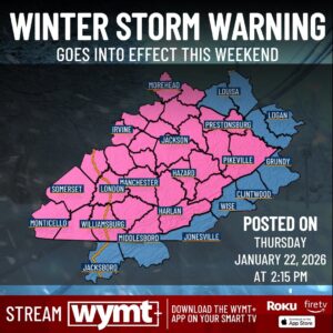
* WHAT…Heavy snow is expected along and north of KY State Route 80 and the Hal Rogers Parkway, with 7 to 12 inches of snow expected and up to a tenth of an inch of sleet and freezing rain. Snow amounts along and south of KY State Route 80 and the Hal Rogers Parkway will range from 3 to 7 inches with a wintry mix of sleet and freezing rain, ranging from 0.1 to 0.4 tenths of an inch. * WHERE…Portions of east central, northeast, south central, and southeast Kentucky. * WHEN…From 7 AM Saturday to 7 AM EST Monday. * IMPACTS…Power outages and tree damage are likely due to the ice. Travel could be nearly impossible. The hazardous conditions could impact the Monday morning commute.
Watches
Winter Storm Watch
- Bell, KY
- Breathitt, KY
- Clay, KY
- Elliott, KY
- Estill, KY
- Floyd, KY
- Harlan, KY
- Jackson, KY
- Johnson, KY
- Knott, KY
- Knox, KY
- Laurel, KY
- Lee, KY
- Leslie, KY
- Letcher, KY
- Magoffin, KY
- Martin, KY
- McCreary, KY
- Menifee, KY
- Morgan, KY
- Owsley, KY
- Perry, KY
- Pike, KY
- Powell, KY
- Pulaski, KY
- Rockcastle, KY
- Rowan, KY
- Wayne, KY
- Whitley, KY
- Wolfe, KY
The Winter Storm Watch has been replaced. Please see the latest information from NWS Jackson KY on this developing situation.
- Buchanan, VA
- Dickenson, VA
- Lawrence, KY
- Logan, WV
- Mingo, WV
- Wayne, WV
* WHAT…A winter storm is expected to bring moderate to major impacts to the region this weekend. Periods of moderate to heavy snow are forecast this weekend with the possibility of a wintry mix of snow, sleet, and freezing rain. * WHERE…Portions of northeast Kentucky, southeast Ohio, southwest Virginia, and central, northeast, northern, southeast, southern, and western West Virginia. * WHEN…From Saturday morning through Monday morning. * IMPACTS…Travel will likely be very difficult to impossible. Heavy snow and ice accumulations could bring down trees and power lines leading to widespread power outages.
- Campbell, TN
- Claiborne, TN
- Lee, VA
- Wise, VA
* WHAT…Heavy mixed precipitation possible. Total mixed snow and sleet accumulations up to 3 inches possible, mainly north of Interstate 40 with highest snow totals near the Kentucky state line. Ice accumulations around one-quarter to one-half of an inch possible. * WHERE…Portions of southwest North Carolina, east Tennessee, and southwest Virginia. * WHEN…From Saturday morning through Sunday evening. * IMPACTS…Roads, and especially bridges and overpasses, will likely become slick and hazardous. Power outages and tree damage are likely due to the ice. Travel could be nearly impossible. * ADDITIONAL DETAILS…This is a complicated forecast and details regarding the location of heaviest snowfall and freezing rain totals remain uncertain. Significant changes could occur over the next 24 to 48 hours so please continue to monitor future forecasts.