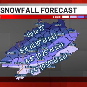
Forecast models indicate that this is a high-impact event. As we approach the weekend, snowfall will begin in the morning hours and continue throughout the day. By Sunday morning, temperatures will start to rise near or above freezing in our southern counties, resulting in a transition to a wintry mix and freezing rain. Overnight on Sunday, temperatures will drop again, leading to a return to snow and causing any liquid water to freeze. Below, you will find a breakdown of the total precipitation and ice amounts expected for your county.
More information can be found here:
A major winter system is moving in from Friday through Monday, and it’s going to bring snow, wintry mix, and dangerously cold temperatures to our region. A Winter Storm Warning has been issued for parts of the WYMT Viewing Area beginning Saturday morning. The WYMT First Alert Weather Team has issued multiple First Alert Weather Days because this is a weather event you need to prepare for now.
Here’s what’s coming
Friday (January 24): Friday is going to be the quiet day. This will be the day that you want to go grocery shopping, or make those last minute errands because Saturday is when things start to get tricky.
Saturday night into Sunday (January 25): This is the trickiest part of the system. We’re expecting a wintry mix — that’s snow mixed with ice — and that combination makes roads really slippery and dangerous. It’s going to get cold, dropping into the low teens Sunday morning. If you’re planning to travel, this is when you’ll want to stay home if you can.
Monday (January 26): There’s a slight chance of snow showers early in the morning, but the real story is the cold. We’re talking dangerously cold highs only in the upper 10s and temperatures dropping below zero Monday night.
After Monday, things improve. By Tuesday, we’ll see highs in the upper 20s, though there’s another chance of snow showers later in the week.
What you need to do right now
- If you commute: Plan for really tough travel conditions from Friday through Monday. Give yourself extra time, slow down, and be extra careful on the roads.
- Stock up before Friday: Get your groceries and supplies now. You don’t want to be out driving in this mess if you don’t have to be.
- Get your driveway ready: Grab some salt, sand, or even kitty litter now. You’ll want it on hand for icy walkways and driveways.
- Check on people you care about: Call your neighbors, elderly relatives, and friends. Make sure they’re prepared for the cold. That below-zero cold can be dangerous.
- Protect your pets: Bring them inside during the coldest parts of the day. And if you have a car, let it warm up before you drive.
The coldest part of this system hits Monday night into Tuesday. Bundle up, stay inside when you can, and don’t underestimate how dangerous that extreme cold can be.
We’re watching this system closely. Stay with the WYMT First Alert Weather team for updates on timing and snow amounts as we get closer to Friday.